
品质至上,客户至上,您的满意就是我们的目标
当前位置: 首页 > 新闻动态
France 3台报道Hiphen公司自动驾驶全植株植物表型成像机器人
发表时间: 点击:1682
来源:北京博普特科技有限公司
分享:


France 3较近报道了法国Hiphen公司与法国农业科学院、INRA联合开发研发的phenomobile植物表型成像系统,配有专有软件分析系统该系统,是当今上自动化程度较高,代表了室外表型研究的较高水准。
系统设计可在2.5m宽通道运行,远程聚焦达到12m,可向各个方向移动,测量头高度可在1.0-4.5m之间进行调整。Phenomobile可沿微型田块按照预设轨迹运行,因彩页了RTK GPS定位,精度可达厘米级。
技术参数
重量 | 7.85t | 转弯半径 | 3m |
宽 | 2.46m | 通量 | 大于100个微型田块/小时 |
长 | 5.2m | 驱动 | 柴油驱动液压与电气系统 |
高 | 3.15m | 履带 | 4个动力转向履带 |
较大速度 | 12km/h | 温控 | 空调箱 |
自主运行 | 10h | 履带设计 | 履带设计防破坏土壤 |
系统有效度
Phenomobile田间高通量表型机器人系统的精度可以达到cm级别,除GPS定位外,每张照片都包含在系统三维空间的位置。
系统耐久性
因为所有的部件都采用先进工业标准,经适当维护,系统可以持续使用,但需要定期对机械进行维护。
传感器平台
每一种相机系统都单独安装在密封壳体内,并绑定在灵活可调的成像盒中,允许灵活的扩展增加传感器。
主要特点
天气保护平台,单独保护传感器
卷帘门在平台下面的对面,充分保护不在使用的传感器
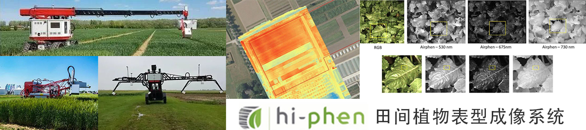
在植物表型研究中,植物的三维结构是获取植物形态和结构参数的基础。Airphen植物表型物联网多光谱测量系统是一个专门用于植物表型研究的高精度多光谱系统,并能够自动计算一系列可靠的形态参数,如多达几十个植被指数如NDVI,MCARI,PRI,Cigreen、株高、植株数量等,airphen功能强大,能获取反映植物生理状态的颜色和其它光谱信息。
在植物表型领域,高光谱相机受到越来越多的重视。高光谱技术可以获取植物对不同光谱的吸收信息,进行植物的生理和组分变化研究。但是,高光谱图像的参数提取非常复杂,获取信息冗余,相机造价很高,对生物领域人员应用是个巨大挑战。此外,成像条件会影响植物光谱的反射,例如叶片角度、传感器的距离等都会对结果造成影响。为了克服这个难题,出现了各种光谱指数,就是用几种不同波长的光谱进行比较从而对数据进行归一化处理。这样,只需要比较几个典型的光谱数据就可以反映植物状态。较典型的就是归一化植被指数NDVI。
在植物表型研究中,当需要计算植被指数例如NDVI时,一无需高光谱相机获取所有波段的光谱图像,只需要用多光谱相机获取典型波段即可。这样既节省了费用,又降低了计算的难度。
Airphen拥有标准的红、绿、蓝和近红外等6个波段。Airphen测量的波段可以从一系列波长列表中定制化选择,以满足不同应用领域的需求波长调节模式((450, 530, 560, 570, 710, 730, 750, 850):6个整合相机带两套波长调节模式:a.450nm–530nm–570nm–675nm–730nm–850nm;b. 450nm–570nm – 675nm–710nm–750nm–850nm。

可计算宽范围的VI值 (植被指数):
NDVI: 归一化差值植被指数;
PRI: 光反射指数
陆地叶绿素指数MTCI, MCARI2等…
拍摄: | 6个同步快门传感器 |
图片尺寸: | 1280×960(tif,12bit) |
获取速度: | 2帧/ 秒 |
波段范围: | 450-900 nm(450,532,568, 675,730,850) |
数据存储: | SD卡存储 |
传感器: | 不同传感器同步(TIR,RGB) |
操作角度: | 25°-60° |
内存: | 40 Go(可达备选240Go) |
操作时间: | 1 h(1电池);2 h(2电池) |
低功耗: | 7W/H |
重量: | 200g |
除了多光谱传感器,该系统还可搭载红外、近红外、高光谱、叶绿素荧光成像等各个成像模块。
应用案例1
本文探讨了利用LiDAR与无人机法进行高通量植物表型性状研究-植物高度估算的方法。我们使用良好浇水以及水分胁迫条件下的小麦基因型进行了实验。利用phénomobile 无人驾驶移动表型车,多次在生长期进行LiDAR测量。配有高分辨率RGB相机的UAV进行了多次飞行,用来追溯数字表明模型(移动的结构信息)。两种技术均可提供3D密度点云,可估算植物高度。植物高度首先界定为z值,99.5%的密度点云情况参见全文。该方法与手工测量植物高度 (RMSE = 3.5 cm) 方法有良好的一致性,在每个微区消除了差异。结果显示,LiDAR和来自移动结构信息的植物高度值非常一致。但是,观测到移动技术获得结构有轻微低估,与LiDAR相比,无人机摄影空间分辨率较差,移动时结构穿透力有限。植物高度的动力学显示其携带了植物胁迫时间以及程度的相关信息。另外,发现植物高度达到较高的时期是可遗传的((H2 > 0.88) ,也是开花时间很好指示参数。文章较后探讨了将植物高度作为全部地上生物量和产量的指示参数。
注:该植物表型成像车为法国Hiphen公司自主研制,专有软件分析系统,是当今上自动化程度较高、较先进的表型成像系统。

部分文章UMT-CAPTE
Scientific Papers2019
30 May 2019
Authors : Xiuliang Jin; Simon Madec; Dan Dutartre; Benoit de Solan; Alexis Comar; Frédéric Baret | Abstract : Total above-ground biomass at harvest and ear density are two important traits that characterize wheat genotypes. Two experiments were carried out in two different sites where several genotypes were grown under contrasted
15 February 2019
Authors : Yan Guangjian; Hu Ronghai; Luo Jinghui; Marie, Weiss; Jiang Hailan; Mu Xihan; Xie Donghui; Zhang Wuming | Abstract : Leaf area index (LAI) is a key parameter of vegetation structure in the fields of agriculture, forestry, and ecology. Optical indirect methods based on the Beer-Lambert law are widely
15 January 2019
Authors : Madec, Simon; Jin, Xiuliang; Lu, Hao; De Solan, Benoit; Liu, Shouyang; Duyme, Florent; Heritier, Emmanuelle; Baret, Frederic | Abstract : Wheat ear density estimation is an appealing trait for plant breeders. Current manual counting is tedious and inefficient. In this study we investigated the potential of convolutional neural
1 November 2018
Authors : Bablet, A.; Vu, P. V. H.; Jacquemoud, S.; Viallefont-Robinet, F.; Fabre, S.; Briottet, X.; Sadeghi, M.; Whiting, M. L.; Baret, F.; Tian, J. | Abstract : Surface soil moisture content (SMC) is known to impact soil reflectance at all wavelengths of the solar spectrum. As a consequence, many
1 October 2018
Authors : Delloye, Cindy; Weiss, Marie; Defourny, Pierre | Abstract : One of the most common approaches to reducing the environmental impact of nitrogen (N) fertilisation in intensive agrosystems is to adjust the N input of the crop requirement. This adjustment is frequently related to the nitrogen nutrition index (NNI)
10 July 2018
Authors : Brede, Benjamin; Gastellu-Etchegorry, Jean-Philippe; Lauret, Nicolas; Baret, Frederic; Clevers, Jan G. P. W.; Verbesselt, Jan; Herold, Martin | Abstract : Land Surface Phenology (LSP) and Leaf Area Index (LAI) are important variables that describe the photosynthetically active phase and capacity of vegetation. Both are derived on the global
1 July 2018
Authors : Roujean, Jean-Louis; Olioso, Albert; Ceschia, Eric; Hagolle, Olivier; Weiss, Marie | Abstract : Satellite Sentinel-2 offers a global coverage of the Earth at the frequency of a few days with pixel size ranging from 10 to 20 meters. Such spatio-temporal resolution fosters an advanced research in agriculture. Accounting
1 July 2018
Authors : Olioso, Albert; Jacob, Frederic; Weiss, Marie | Abstract : The SAIL-Thermique model was developed to simulate land surface emissivity. It is adapted from the original SAIL model. A specific experiment was set-up over a soybean canopy for evaluating spectral emissivity simulations. Multispectral data were obtained thanks to a
27 April 2018
Authors : Brede, Benjamin; Gastellu-Etchegorry, Jean-Philippe; Lauret, Nicolas; Baret, Frederic; Clevers, Jan G. P. W.; Verbesselt, Jan; Herold, Martin | Abstract : Land Surface Phenology (LSP) and Leaf Area Index (LAI) are important variables that describe the photosynthetically active phase and capacity of vegetation. Both are derived on the global
1 April 2018
Authors : Liu, Shouyang; Baret, Frederic; Andrieu, Bruno; Abichou, Mariem; Allard, Denis; de Solan, Benoit; Burger, Philippe | Abstract : This work investigates the spatial distribution of wheat plants and its consequences on the canopy structure. A set of RGB images were taken from nadir on a total 14 plots
20 March 2018
Authors : Jiang, Jingyi; Comar, Alexis; Burger, Philippe; Bancal, Pierre; Weiss, Marie; Baret, Frederic | Abstract : Background: Leaf biochemical composition corresponds to traits related to the plant state and its functioning. This study puts the emphasis on the main leaf absorbers: chlorophyll a and b (C-ab), carotenoids (C-c), water
1 March 2018
Authors : Franch, Belen; Vermote, Eric F.; Roger, Jean-Claude; Murphy, Emilie; Becker-Reshef, Inbal; Justice, Chris; Claverie, Martin; Nagol, Jyoteshwar; Csiszar, Ivan; Meyer, Dave; Baret, Frederic; Masuoka, Edward; Wolfe, Robert; Devadiga, Sadashiva | Abstract : The Advanced Very High Resolution Radiometer (AVHRR) sensor provides a unique global remote sensing dataset that
1 December 2017
Authors : Liu, Shouyang; Baret, Fred; Abichou, Mariem; Boudon, Fred; Thomas, Samuel; Zhao, Kaiguang; Fournier, Christian; Andrieu, Bruno; Irfan, Kamran; Hemmerle, Matthieu; de Solan, Benoit | Abstract : The use of active remote sensing techniques based on light detection and ranging (LiDAR) was investigated here to estimate the green area
1 November 2017
Authors : Madec, Simon; Baret, Fred; de Solan, Benoit; Thomas, Samuel; Dutartre, Dan; Jezequel, Stephane; Hemmerle, Matthieu; Colombeau, Gallian; Comar, Alexis | Abstract : The capacity of LiDAR and Unmanned Aerial Vehicles (UAVs) to provide plant height estimates as a high-throughput plant phenotyping trait was explored. An experiment over wheat
1 October 2017
Authors : Li, Wenjuan; Baret, Frederic; Weiss, Marie; Buis, Samuel; Lacaze, Roselyne; Demarez, Valerie; Dejoux, Jean-francois; Battude, Marjorie; Camacho, Fernando | Abstract : A wide range of ecological, agricultural, hydrological and meteorological applications at local to regional scales requires decametric biophysical data. However, before the launch of SENTINEL-2A, only few
1 September 2017
Authors : Yan Guangjian; Hu Ronghai; Luo Jinghui; Marie, Weiss; Jiang Hailan; Mu Xihan; Xie Donghui; Zhang Wuming | Abstract : Accurate estimation of leaf chlorophyll content (Cab) from remote sensing is of tremendous significance to monitor the physiological status of vegetation or to estimate primary production. Many vegetation indices
1 July 2017
Authors : Jacob, Frederic; Lesaignoux, Audrey; Olioso, Albert; Weiss, Marie; Caillault, Karine; Jacquemoud, Stephane; Nerry, Francoise; French, Andrew; Schmugge, Thomas; Briottet, Xavier; Lagouarde, Jean-Pierre | Abstract : We investigated the use of multispectral thermal imagery to retrieve land surface emissivity and temperature. Conversely to concurrent methods, the temperature emissivity separation
Estimates of plant density of wheat crops at emergence from very low altitude UAV imagery
1 June 2017
Authors : Jin, Xiuliang; Liu, Shouyang; Baret, Frederic; Hemerle, Matthieu; Comar, Alexis | Abstract : Plant density is useful variable that determines the fate of the wheat crop. The most commonly used method for plant density quantification is based on visual counting from ground level. The objective of this study
1 May 2017
Authors : Liu, Shouyang; Baret, Fred; Andrieu, Bruno; Burger, Philippe; Hemmerle, Matthieu | Abstract : Crop density is a key agronomical trait used to manage wheat crops and estimate yield. Visual counting of plants in the field is currently the most common method used. However, it is tedious and time
1 May 2017
Authors : Yan Guangjian; Hu Ronghai; Luo Jinghui; Marie, Weiss; Jiang Hailan; Mu Xihan; Xie Donghui; Zhang Wuming | Abstract : Background: Plant density and its non-uniformity drive the competition among plants as well as with weeds. They need thus to be estimated with small uncertainties accuracy. An optimal sampling
1 January 2017
Authors : Weiss, Marie; Baret, Frederic | Abstract : In the context of precision viticulture, remote sensing in the optical domain offers a potential way to map crop structure characteristics, such as vegetation cover fraction, row orientation or leaf area index, that are later used in decision support tools. A

1 December 2016
Authors : Baret, Frederic | Abstract : The supply of biophysical variables derived from satellite observations serves several applications related to agriculture, the environment, resource management and the climate. Moreover, these same variables may be acquired at a range of scales:. -at the very local level, the use of precision
1 November 2016
Authors : Verger, Aleixandre; Kandasamy, Sivasathivel; Baret, Frederic | Abstract : Time series processing is an important ingredient of a biophysical algorithm in order to get the expected continuous and smooth dynamics required by many applications. Several temporal techniques have been proposed to reduce noise and fill gaps in the
1 November 2016
Authors : Vuolo, Francesco; Zoltak, Mateusz; Pipitone, Claudia; Zappa, Luca; Wenng, Hannah; Immitzer, Markus; Weiss, Marie; Baret, Frederic; Atzberger, Clement | Abstract : This technical note presents the first Sentinel-2 data service platform for obtaining atmospherically-corrected images and generating the corresponding value-added products for any land surface on Earth. Using
1 October 2016
Authors : Steven, Michael D.; Malthus, Timothy J.; Baret, Frederic | Abstract : No abstract.
10 June 2016
Authors : Gouache, David; Beauchene, Katia; Mini, Agathe; Fournier, Antoine; de Solan, Benoit; Baret, Fred; Comar, Alexis | Abstract : Digital and image analysis technologies in greenhouses have become commonplace in plant science research and started to move into the plant breeding industry. However, the core of plant breeding work
1 January 2016
Authors : Tagliabue, Giulia; Panigada, Cinzia; Colombo, Roberto; Fava, Francesco; Cilia, Chiara; Baret, Frederic; Vreys, Kristin; Meuleman, Koen; Rossini, Micol | Abstract : The accurate mapping of forest species is a very important task in relation to the increasing need to better understand the role of the forest ecosystem within


")


